The Impact of Geography on Indian History
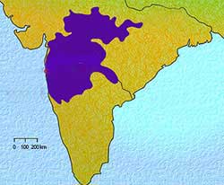
The Vindhya and Satpura mountains along with Narmada and the Tapti rivers form the great dividing line between northern and southern India. The plateau to the south of the Vindhya Mountains is known as the Deccan plateau. It consists of volcanic rock, which is different from the northern mountains. As these rocks are easier to cut into, we find a number of rock-cut monasteries and temples in the Deccan.
 |
| The Deccan plateau |
In the southern end remains the famous Palghat Pass. It is the passage across the Ghats from the Kaveri valley to the Malabar Coast. The Palghat Pass was an important trade route for the Indo-Roman trade in the ancient times. The Anaimudi is the highest peak in the southern peninsula. Doddapetta is another highest peak in the Western Ghats. The Eastern Ghats are not very high and have several openings caused by the eastward flow of the rivers into the Bay of Bengal. The port cities of Arikkamedu, Mamallapuram and Kaveripattanam were situated on the Coramandal coast.
Information related to the search:
The Impact of Geography on Indian History, india, history, ghats, plateau, western, southern, deccan, mountains, coast, eastern, peninsula, geography, impact, trade, indian, vindhya, north, palghat, pass, peak, highest, malabar, bengal, ancient, south, northern, coramandal, rivers, rock

